
Last updated: July 2026
Many people are searching for the Pataudi Master Plan 2041. This article explains it in simple, easy words. This plan is officially called the “Draft Development Plan for Controlled Area Pataudi-Haily Mandi, 2041.” It was made by the Department of Town and Country Planning, Haryana, under Drawing No. DTP(G) 2572/2022, dated 25 August 2022.
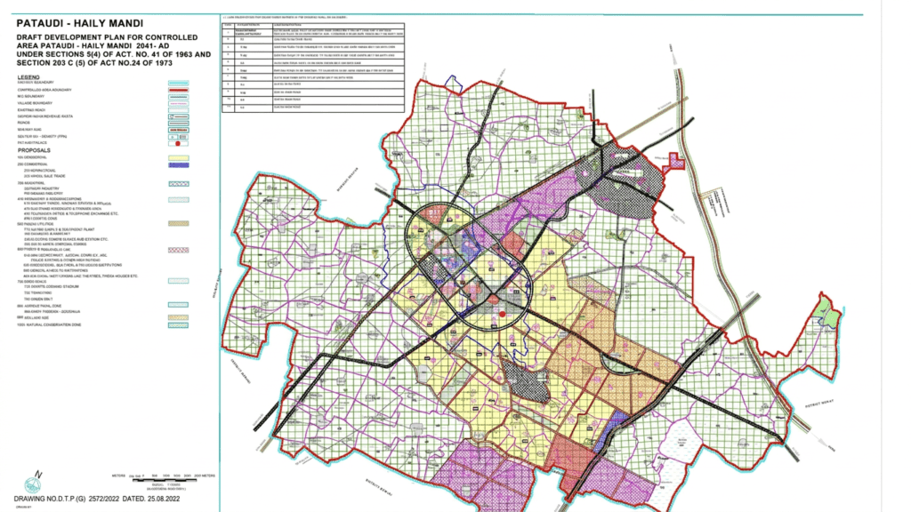
(Important note: This is marked as a "Draft" plan, not a final approved plan. A draft plan can still change before it is finally notified by the government. Always check the official website for the latest, confirmed status before making any decision.)
What Is the Pataudi Master Plan 2041?
This plan is a map made by the government. It shows how land around Pataudi and Haily Mandi should be used up to the year 2041. It marks out areas for homes, shops, factories, roads, and open land, so that the town grows in an organised way.
This plan was made under two laws:
- Section 5(4) of the Punjab Scheduled Roads and Controlled Areas Act, 1963 (Act No. 41 of 1963)
- Section 203C(5) of the Haryana Municipal Corporation Act, 1973 (Act No. 24 of 1973)
Using two laws together shows that this plan also covers municipal corporation areas, not just controlled land outside town limits.
Who Prepared This Plan?
The plan was prepared by the Department of Town and Country Planning (TCP), Haryana. This is the same government department responsible for planning towns across the state, including Gurugram, Rewari, and other NCR towns.
Main Land Use Categories in the 2041 Plan
The legend on the map lists these main proposal categories:
1. Residential (100)
Land kept for housing and residential colonies. This is shown as the largest coloured zone on the map, spread across many sectors.
2. Commercial (200)
This includes:
- Retail Trade (210) – shops and markets for everyday buying
- Wholesale Trade (220) – larger trading and bulk-goods areas
3. Industrial (300)
This includes:
- Light Industry (320)
- Medium Industry (330)
These zones are meant for factories and manufacturing units that create local jobs.
4. Transport and Communications (400)
This includes:
- Railway yards, railway stations and sidings (410)
- Bus stands, workshops and parking areas (420)
- Telegraph office and telephone exchange (450)
- Logistic zone (480)
5. Public Utilities (500)
This includes:
- Water supply and treatment plant (510)
- Drainage and sanitary systems (520)
- Electric power plants and sub-stations (530)
- Solid waste disposal works (550)
6. Public and Semi-Public Use (600)
This includes:
- Mini secretariat, judicial complex, jail, police station and other institutions (610)
- Educational, cultural and religious institutions (620)
- Medical and health institutions (630)
- Cultural institutions like theatres and opera houses (640)
7. Open Space (700)
This includes:
- Sports ground and stadium (710)
- Town park (720)
- Green belt (750)
8. Agricultural Zone (800)
This includes normal agricultural land and dairy farming/goshala use (890).
9. Mixed Land Use (900)
Areas where more than one type of use, like homes and small shops, can exist together.
10. Natural Conservation Zone (1000)
Land kept protected from construction to preserve nature.
Road Network and Green Belts
One special feature of the 2041 draft plan is a detailed road classification table. It lists different road categories, from the large KMP/Palwal Expressway down to smaller local roads, along with planned road widths and green belts (tree-covered buffer strips) running alongside many of these roads. This shows that road widening and green buffers are a major focus of this plan, likely to reduce future traffic problems and improve air quality along busy roads.
(For the exact width of each road category, please check the official table on the notified map, as small text on scanned documents can be hard to read accurately. This article avoids guessing exact numbers to stay accurate.)
Key Roads and Connectivity Shown in the Plan
- KMP Expressway / Palwal Expressway – a major expressway shaping development along its route
- Multiple existing roads planned for widening, with green belts on both sides
- Local roads (marked as 30m, 45m, 60m, and similar categories) connecting sectors within the plan
Good road planning like this generally improves property value and reduces travel time for residents.
Difference Between the 2041 Draft Plan and Earlier Plans
Pataudi has had more than one planning document over the years, including an earlier version referring to a 2051 target year. Plans get revised because:
- Population and housing demand change over time
- Roads like NPR and KMP Expressway open new connectivity
- Government policy on urban growth in the NCR region keeps evolving
If you are checking property records or planning to build, always confirm which version of the plan is currently active and legally notified, since a “draft” plan can be revised before final approval.
How to Check the Official Pataudi Master Plan 2041
Always confirm details directly from:
- Department of Town and Country Planning, Haryana – tcpharyana.gov.in
- The local planning office in the Gurgaon or Rewari planning circle
Avoid depending only on unofficial websites, since maps are sometimes uploaded with wrong labels or outdated versions.
Check Pataudi Master PLan 2031 : Click here
Frequently Asked Questions
What is the Pataudi Master Plan 2041?
It is a draft government land-use plan for the Pataudi-Haily Mandi controlled area, showing planned zones for housing, commerce, industry, and roads up to the year 2041.
Is the Pataudi Master Plan 2041 final?
No. The map is officially marked as a “Draft Development Plan,” which means it can still be revised before final government notification.
What is new in the 2041 plan compared to older Pataudi plans?
It adds a detailed road classification table with planned road widening and green belts, and it is prepared under an additional municipal corporation law, showing wider coverage.
Conclusion
The Pataudi Master Plan 2041 gives a detailed, organised picture of how Pataudi-Haily Mandi may grow in future — with clear space for homes, industry, roads, and green areas. Since it is currently a draft, residents, land owners, and property buyers should keep checking the official Town and Country Planning Department, Haryana website for the latest confirmed version before making any major decisions.
Disclaimer: This article is written for general information only. This plan is marked as a draft and may change before final approval. Please verify the latest official status from the Town and Country Planning Department, Haryana, or consult a legal/real estate expert before making any property decision.